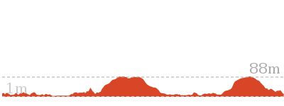
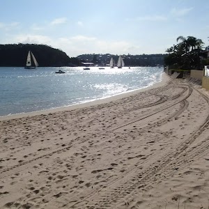
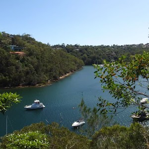
Manly to Seaforth Oval


5 hrs 45 mins

624 m
Moderate track


(0km) Manly Wharf → Int of King and Lauderdale avenues

1.9 km
38 mins
67m
-52m
Very easy
Continue straight: From the beach, this walk follows the footpath up the hill keeping the water to the left. The path winds behind the houses through the open parkland, following the water. The walk passes picnic chairs and some nice views before coming out of the park at the end of Bolingbroke Parade.
Turn left: From the end of the road, the walk follows the wide footpath, keeping the water to the left. The concrete footpath then winds around the back of some apartment buildings through some open parkland. Soon the footpath heads up a hill to come to Lauderdale Avenue.
Veer left: From the intersection, the walk follows ‘The Spit’ sign up the footpath along Lauderdale Avenue. After passing a couple of houses the footpath comes to an intersection at the top of King Avenue.
(1.95km) Int of King and Lauderdale avenues → End of King avenue
220 m
5 mins
7m
-11m
Very easy
(2.16km) End of King Avenue → Int of Beach Ln and North Harbour St
230 m
5 mins
5m
-12m
Easy track
North Harbour Reserve
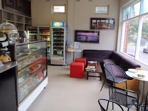
Shop at the Park
(2.39km) Int of Beach Ln and North Harbour St → Int of Clarence and North Harbour Sts
120 m
3 mins
8m
0m
Very easy
(2.51km) Int of Clarence and North Harbour Sts → Int of Gourlay Avenue and Clarence Street footpath
100 m
2 mins
2m
-5m
Very easy
(2.61km) Int of Gourlay Avenue and Clarence Street footpath → End of Gourlay Avenue
250 m
5 mins
4m
-12m
Easy track
(2.85km) End of Gourlay Avenue → South end of Forty Baskets Reserve
450 m
9 mins
21m
-19m
Very easy
Continue straight: From the intersection, this walk heads away from the stairs and follows the sealed footpath, keeping the water on the left. The path gently winds down the hill to soon come to another intersection with a set of stairs and handrail (uphill to the right).
Continue straight: From the intersection, this walk follows the footpath down the hill, to the toilet block, keeping the water below to the left.
Continue straight: From the toilet block, this walk follows the footpath (keeping the water on the left) through Forty Baskets Reserve. The track passes the swings, picnic tables, water fountain and the ocean pool, then heads around the back of the beach to the signposted intersection of the ‘Manly Scenic Walk Alternate Route’.
(3.3km) South end of Forty Baskets Reserve → Int. Alternate High Tide Route and Manly Scenic Walkway
560 m
15 mins
32m
-31m
Hard track
Continue straight: From the end of Beatty St, the walk heads past the signs and down to a wooden boardwalk. The track then climbs up to a sign posted intersection.
Turn left: From the intersection, this walk follows the sign to ‘Manly’ along the flat track. The walk soon continues down sets of alternating wooden and stone steps, which lead to a signposted intersection. Now Turn right to rejoin the main walk .
(3.3km) South end of Forty Baskets Reserve → Reef Beach platform
590 m
11 mins
17m
-16m
Moderate track
Continue straight: From the intersection, this walk follows the sign to ‘The Spit via Reef Beach’, keeping the water on the left. The track is flat for a short time before heading down past a toilet block and then coming to a bench and platform behind Reef Beach.
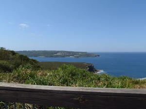
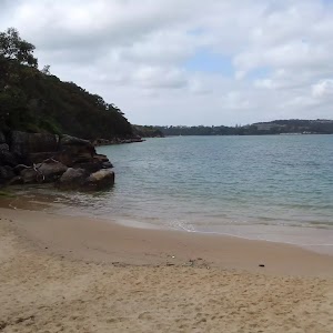
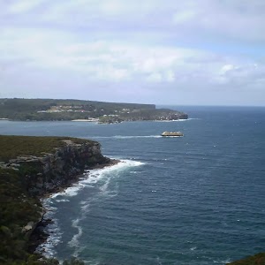
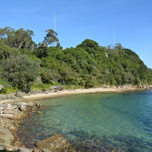
Reef Beach
(3.89km) Reef Beach platform → Crater Cove Lookout
1.1 km
23 mins
86m
-15m
Moderate track
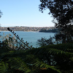
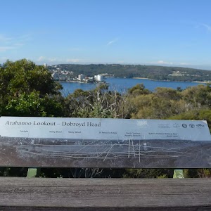
Continue straight: From the intersection, this walk follows the sign to ‘The Spit’, up the hill. The track heads up the hill, with the heath on the right becoming thicker as the track gains altitude. As the track winds up the hill, it reaches a rock platform with great views over Manly, before continuing up to the signposted intersection with track to Arabanoo Lookout to the right.
Veer left: From the intersection, this walk follows ‘The Spit’ arrow along the hillside as it winds through the thick scrub to the start of a boardwalk. The walk leads further around the hillside to the edge of the park and down onto the fenced Crater Cove lookout.
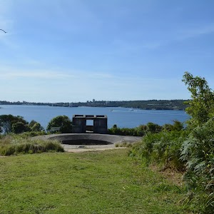
Crater Cove Lookout
(5.02km) Crater Cove Lookout → Grotto Point Engravings track
670 m
15 mins
19m
-38m
Moderate track
Turn left: From the intersection, this walk follows the Arabanoo Walk, keeping the water on the left. The track continues away from the rock platform for a short time, coming to an unnamed lookout on another rock platform.
Continue straight: From the intersection, this walk heads along the hillside keeping the harbour below and to the left of the track. The walk crosses several separate sections of boardwalk and rock platforms, coming to the intersection with the signpost ‘Castle Rock Beach 800m’.
Continue straight: From the intersection, this walk follows the ‘Castle Rock Beach 800m’ sign along the bush track and down the stone steps, keeping the ocean to the left. The track winds down the hill until it flattens out at the intersection with a short track (heading to the Grotto Point engravings track) on the left.
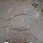
(5.69km) Grotto Point Engravings track → Grotto Point Engravings
40 m
1 mins
2m
0m
Moderate track
Grotto Point Engravings

(5.69km) Grotto Point Engravings track → Int of Grotto Point Lighthouse and Manly to Spit tracks
110 m
3 mins
1m
-8m
Moderate track
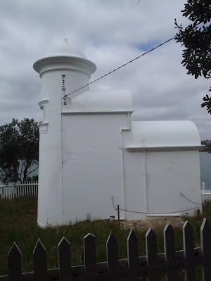
(5.8km) Int of Grotto Point Lighthouse and Manly to Spit tracks → Grotto Point Lighthouse
550 m
11 mins
4m
-52m
Moderate track
Veer right: From the intersection, this walk winds down the hill, passing an old, blank signpost. The track wanders through dense bush and along the ridge, flattening out for a while until it drops down another hill towards the end of the point, coming to the Grotto Point Lighthouse. At the end of this side trip, retrace your steps back to the main walk then Turn left.
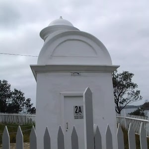
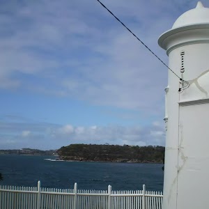
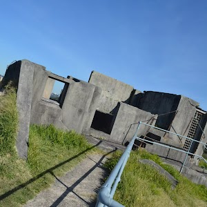
Grotto Point Lighthouse
(5.8km) Int of Grotto Point Lighthouse and Manly to Spit tracks → Int of Manly to Spit Track and Castle Rock Beach steps
400 m
11 mins
16m
-46m
Moderate track
Continue straight: From the rest area, this walk follows the bush track, keeping the water on the left, heading around the headland and winding along the side of the hill. The track passes some fenced-off rock platforms and heads down some rock steps to a wooden bridge. The walk crosses the bridge and continues along the bush track, winding steeply down some concrete steps to the bottom. The track continues back up and along, winding through the bush until it comes across a short boardwalk then to a signposted intersection of the Castle Rock beach footpath.
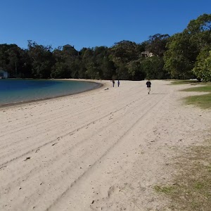
(6.19km) Int of Manly to Spit Track and Castle Rock Beach steps → Castle Rock Beach
50 m
1 mins
0m
-11m
Moderate track
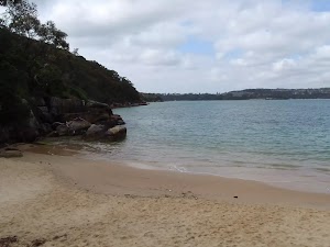
Castle Rock Beach
(6.19km) Int of Manly to Spit track and Castle Rock Beach steps → Int of Manly to Spit track and Ogilvy Road steps
30 m
1 mins
3m
0m
Moderate track
(6.22km) Int of Manly to Spit track and Ogilvy Road steps → Clontarf Reserve (Clonny’s)
1.2 km
25 mins
32m
-53m
Moderate track
Continue straight: From the intersection, this walk follows ‘The Spit’ sign, keeping the water to the left. The track heads down the rocky steps and along the passage of the rocks to a signposted intersection, with the tiny Board Beach down to the left.
Continue straight: From the intersection, this walk follows the sign to ‘The Spit’, heading up the stone steps and then around the hill. The track undulates mildly before turning left and down onto a beach, passing a ‘Spit to Manly walkway’ information sign. From the bottom of the stairs, this walk heads across the beach, passing one house to come to the sign pointing along the ‘M.S.W. High Tide Access via Monash Cres’ track.
Continue straight: From the southern end of Clontarf Beach, the walk follows the beach passing the houses. After the last house, the walk continues past the large concrete structure and into the Clontarf Reserve. The walk then heads across the open grassy area, passing the toilets and picnic shelter on the right, then rounds to the front of Clonny’s Cafe.
Clonny’s

Clontarf Reserve
(7.4km) Clontarf Reserve (Clonny’s) → Int. Sandy Bay Rd and Fairbairn Ave
480 m
9 mins
14m
-11m
Moderate track
Turn right: From Clontarf Marina, this walk heads over the pedestrian crossing and up the stairs. The track passes the houses then leads down the stairs at the end of the clearing, back to Sandy Bay Rd. Once on the road, the walk turns right and heads alongside the bay until coming to an intersection with Sandy Bay Rd and Fairbairn Ave.
(7.88km) Int. Sandy Bay Rd and Fairbairn Ave → End of Sandy Bay Rd
40 m
1 mins
2m
0m
Very easy
(7.92km) End of Sandy Bay Rd → Int. Ellery’s Punt Reserve Rd and Manly Scenic Walkway
980 m
22 mins
51m
-51m
Moderate track
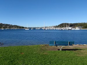
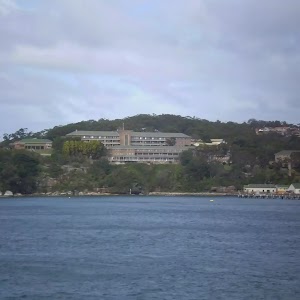
Ellery’s Punt Reserve
(8.91km) Int. Ellery’s Punt Reserve Rd and Manly Scenic Walkway → Int. Battle Boulevard and Manly Rd
230 m
5 mins
11m
0m
Moderate track
Continue straight: From the end of the cul-de-sac, this walk follows Battle Bvd up the road to the car park just near the intersection with Manly Road.
(9.14km) Int. Battle Boulevard and Manly Rd → Top of the Gallipoli Steps
160 m
4 mins
40m
0m
Moderate track
(9.3km) Top of the Gallipoli Steps → Int of Sangrado Street and the Powder Hulk Bay footpath
2.1 km
46 mins
82m
-103m
Easy track
Turn left: From the intersection, the walk follows the track marker along the narrow road, heading down the hill with the Seaforth Scout Hall on the right. The walk continues down to the intersection at the top of the concrete steps (heading down the hill to the right).
(11.36km) Int of Sangrado Street and the Powder Hulk Bay footpath → Top of the Jenner Street Steps
260 m
9 mins
35m
-31m
Moderate track
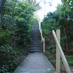
Turn right: From the intersection, the walk follows the track marker up the concrete steps. The walk follows the steps all the way up the hill to a driveway, which it crosses and continues up the steps on the other side, climbing up to the top of the hill at the intersection with Jenner Street.
(11.62km) Top of the Jenner Street Steps → Wakehurst Pkwy Bus stop
1.6 km
30 mins
78m
-25m
Moderate track
(13.22km) Wakehurst Pkwy Bus stop → Seaforth Oval
530 m
9 mins
23m
-4m
Moderate track
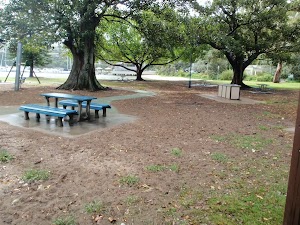
Veer left: From the intersection, the walk heads across the long grassy clearing towards the play equipment. Upon reaching the play equipment, the walk then follows the asphalt path, heading up on the right-hand side of the club house to the car park. Here, it turns left, passing the club house and coming to the information signs on the other side of the car park.
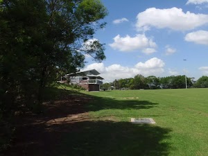
Seaforth Oval
Maps for the Manly to Seaforth Oval walk
You can download the PDF for this walk to print a map.These maps below cover the walk and the wider area around the walk, they are worth carrying for safety reasons.
| Parramatta River | 1:25 000 Map Series | 91303N PARRAMATTA RIVER | NSW-91303N |
| Sydney Heads | 1:25 000 Map Series | 91302N SYDNEY HEADS | NSW-91302N |
| Sydney | 1:100 000 Map Series | 9130 SYDNEY | 9130 |
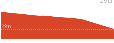
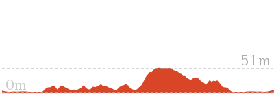
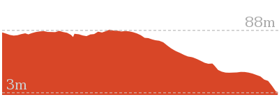
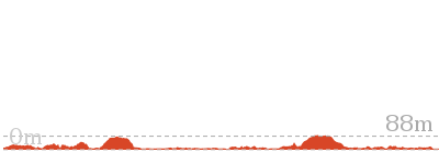
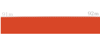
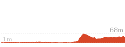
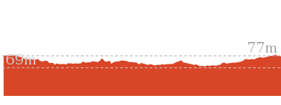
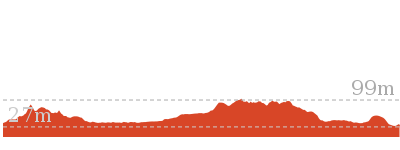
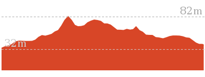
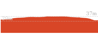
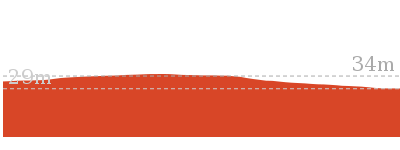
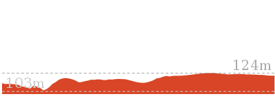
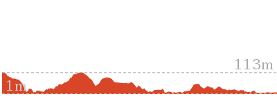
Cross sectional view of the Manly to Seaforth Oval bushwalking track
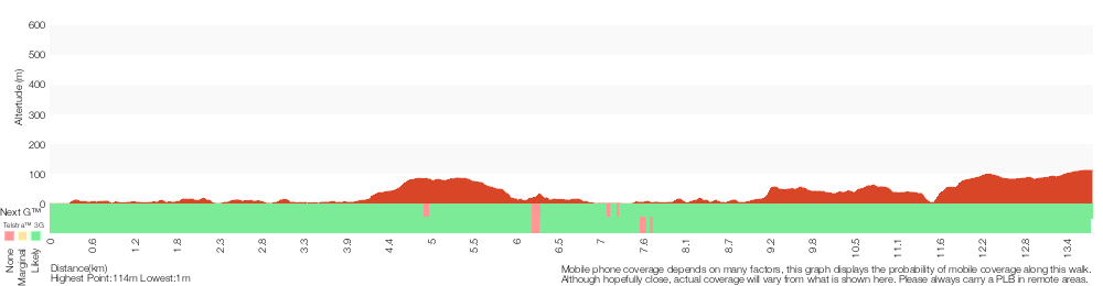
Analysis and summary of the altitude variation on the Manly to Seaforth Oval

Overview of this walks grade – based on the AS 2156.1 – 2001
Under this standard, a walk is graded based on the most difficult section of the walk.
| Length | 13.7 km | ||
| Time | 5 hrs 45 mins | ||
| . | |||
| Grade 3/6 Moderate track |
AS 2156.1 | Gradient | Short steep hills (3/6) |
| Quality of track | Formed track, with some branches and other obstacles (3/6) | ||
| Signs | Directional signs along the way (3/6) | ||
| Experience Required | Some bushwalking experience recommended (3/6) | ||
| Weather | Storms may impact on navigation and safety (3/6) | ||
| Infrastructure | Limited facilities, not all cliffs are fenced (3/6) |
Some more details of this walks Grading
Here is a bit more details explaining grading looking at sections of the walk
Gradient
5km of this walk has gentle hills with occasional steps and another 5km has short steep hills. The remaining (3.7km) is flat with no steps.
Quality of track
6km of this walk follows a smooth and hardened path and another 4.4km follows a clear and well formed track or trail. The remaining (3km) follows a formed track, with some branches and other obstacles.
Signs
Around 11km of this walk is clearly signposted, whilst the remaining 2.7km has directional signs at most intersection.
Experience Required
Around 13km of this walk requires no previous bushwalking experience, whilst the remaining 450m requires some bushwalking experience.
weather
Around 14km of this walk is not usually affected by severe weather events (that would unexpectedly impact safety and navigation), whilst the remaining 240m is affected by storms that may impact your navigation and safety.
Infrastructure
Around 12km of this walk is close to useful facilities (such as fenced cliffs and seats), whilst the remaining 2.2km has limited facilities (such as not all cliffs fenced).
Similar walks

60 m Return
3 mins
Moderate track

200 m Return
30 mins
Moderate track
1.7 km Return
1 Hr
Moderate track

2 km Return
1 Hr
Moderate track

2.5 km Circuit
1 Hr
Hard track

3.6 km Circuit
1 hr 30 mins
Hard track
3.6 km Return
2 hrs
Moderate track
4.3 km One way
2 hrs 30 mins
Hard track
8.7 km Circuit
4 hrs
Moderate track
9.1 km One way
3 hrs 45 mins
Moderate track

10.4 km One way
5 hrs
Hard track
18.9 km One way
8 hrs
Hard track
22.6 km One way
9 hrs 45 mins
Hard track

Other Nearby walks
142 m Return
15 mins
Very easy
6.1 km One way
2 hrs 30 mins
Hard track
762 m Circuit
30 mins
Very easy

7.3 km Circuit
3 hrs
Moderate track

3.2 km Return
1 hr 30 mins
Moderate track
762 m Return
30 mins
Moderate track
664 m Return
30 mins
Easy track
930 m Return
30 mins
Hard track

3.1 km One way
2 hrs
Moderate track

1.9 km Circuit
1 Hr
Moderate track

2.2 km One way
45 mins
Moderate track
10 km One way
4 hrs 30 mins
Hard track
Plan your trip to and from the walk here
The Manly to Seaforth Oval walk starts at the Manly Wharf (gps: -33.799562, 151.28427)Your transport options to Manly Wharf are by;
(get details)
The Manly to Seaforth Oval ends at the Seaforth Oval (gps: -33.781966, 151.23725)
Your transport options to Seaforth Oval are by;
(get details)


Short URL = http://wild.tl/mtso
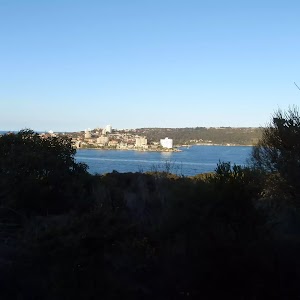
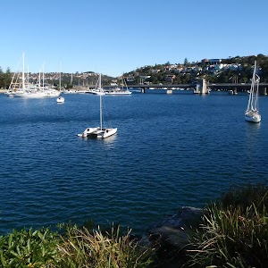
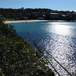
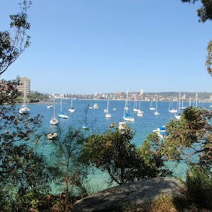
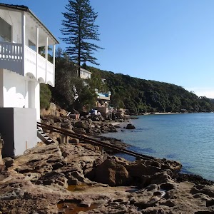
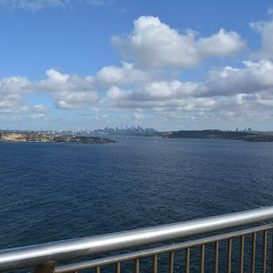
Gallery images
There are other downloads I am still working on.
You will probably need to login to access these — still all free.
* KML (google earth file)
* GPX (GPS file)
Special Maps/ brochures
* A3 topo maps
* PDF with Lands Topo map base
* PDF with arial image (and map overlay)
I wanted to get the main site live first, this extra stuff will come in time.
Happy walking
Matt 🙂
Comments