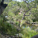
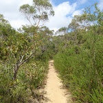
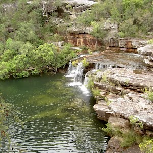
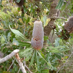
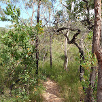
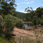
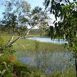
Following Heathcote Creek, this walk is a great overnight walk, often used to introduce new walkers to overnight hikes. A well-signposted and defined track leads you to a campsite with a reasonable level of facilities. There are great views of Heathcote Creek along the way, and many of Heathcote’s varied environments to enjoy. Definitely worth the time to head down to Lake Eckersley, which is perfectly placed for lunch on the first day.
Heathcote to Waterfall Overnight Walk


2 Days
10.8 km One way

503 m
Hard track


(0km) Heathcote Railway Station → End of Freeman Rd

1 km
17 mins
4m
-24m
Very easy
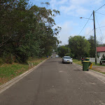
From the station, this walk follows the footpath towards the highway, passing the left side of the car park, until it reaches the highway, which it crosses at the traffic lights. The walk continues along Oliver Street for a while before coming to the intersection with Boundary Road. Here, this walk turns left, following the road for a short distance before taking the first right onto Freemans Road and continuing past the large scout camp, to the end of the road, where it comes to the intersection with the management trail at the corner of Bella Vista Street.
(1.03km) End of Freeman Rd → Int. of Mirang and Mirang Pool Tracks
1.7 km
37 mins
49m
-134m
Moderate track
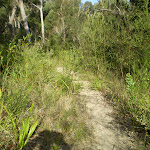
Veer left: From the intersection, this walk follows the management trail, crossing under the high tension power lines and bending around to the right a short distance, before coming back around to the left and passing a management trail (which heads behind some houses). The walk continues down the hill, passing another trail on the left as the hill steepens and comes to an intersection with a rough bush track, opposite the power line tower at the bottom of the trail.
Turn right: From the intersection, the walk follows the bush track on the opposite side of the management trail to the power line tower. The walk passes a burnt-out car shell before turning down the long steep hill and winding down to the ‘T’ intersection with a wider track.
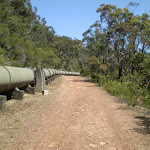
Turn right: From the intersection, the walk follows the track heading down along the side of the hill and through the thick bush. After a short while, the track comes to a large concrete pipeline, crossing it at the metal platform to the intersection with the management trail.
Continue straight: From the intersection, this walk follows the ‘Mirang Pool’ arrow along the asphalt trail down the long hill. After a short while, the trail bends around to the left, turning back towards the pipeline, and continues downhill until it flattens out and crosses a bridge at the pipeline. From here, the walk continues along the management trail, following the pipeline (with Heathcote Creek down the hill on the right) for a while before coming to the signposted intersection with the Mirang Pool track.
Turn right: From the intersection, the walk follows the bush track on the opposite side of the management trail to the power line tower. The walk passes a burnt-out car shell before turning down the long steep hill and winding down to the ‘T’ intersection with a wider track.
Turn right: From the intersection, the walk follows the track heading down along the side of the hill and through the thick bush. After a short while, the track comes to a large concrete pipeline, crossing it at the metal platform to the intersection with the management trail.
Continue straight: From the intersection, this walk follows the ‘Mirang Pool’ arrow along the asphalt trail down the long hill. After a short while, the trail bends around to the left, turning back towards the pipeline, and continues downhill until it flattens out and crosses a bridge at the pipeline. From here, the walk continues along the management trail, following the pipeline (with Heathcote Creek down the hill on the right) for a while before coming to the signposted intersection with the Mirang Pool track.
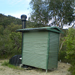
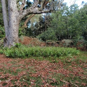
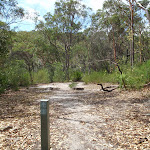
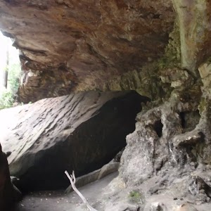
Mirang Pool camping ground
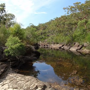
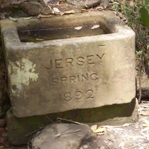
This campsite is nestled in Heathcote National Park, with walk-in access from Heathcote Station. The campsite is near Mirang Pool on Heathcote Creek – there is a signpost at the top of the stairs, leading down to the pools from the management trail above. There are no facilities provided at the campsite, and you will need to carry in your own water and fuel stove.
(2.7km) Int. of Mirang and Mirang Pool Tracks → Int of Pipeline Track and Mirang Rd Servicetrail
340 m
8 mins
13m
-24m
Moderate track
Continue straight: From the intersection, this walk follows the ‘Lake Eckersley’ arrow along the management trail, keeping the pipe line to the left, as it heads through the bush. After a while, the trail does a large ‘S’ bend, crossing the pipeline twice as before passing through a gate and up to the intersection with the Mirang Road service trail.
(3.04km) Int of Pipeline Track and Mirang Rd Servicetrail → Battery Causeway
1 km
21 mins
46m
-32m
Moderate track
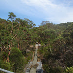
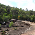
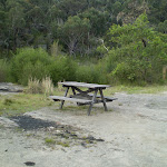
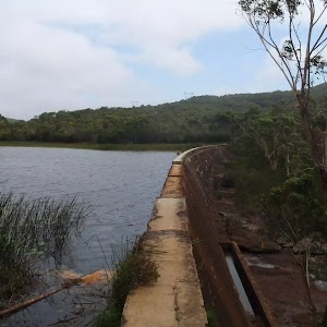
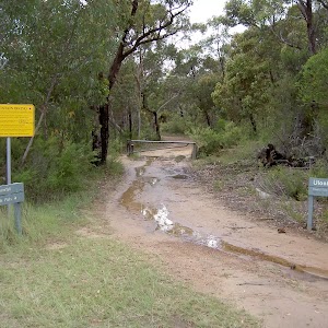
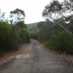
Continue straight: From the intersection, the walk follows the asphalt management trail, keeping Heathcote Creek and the valley to the right as the trail rounds a bend and heads up run parallel with the pipeline as the trail becomes gravel. From here, the walk continues along the management trail, keeping the pipeline on the left for about 750m. The walk then crosses over the pipeline using a timber bridge and 160m further along the management trail the walk passes a picnic table and crosses Heathcote Creek at the concrete Battery Causeway. (Here you may notice the ‘Bullawarring Track – Waterfall 7km’ sign[1] up to your left).
(4.06km) Battery Causeway → Lake Eckersley
500 m
11 mins
14m
-42m
Moderate track
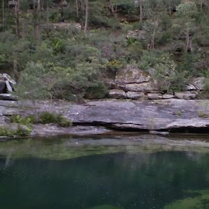
Veer right: From the intersection, this walk follows the management trail, heading up the hill with the creek down to the right. The trail does a sharp ‘U’ turn to the left, and continues up the hill to the signposted intersection of the ‘Lake Eckersley Track’.
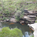
Turn right: From the intersection, this walk follows the bush track beside the signpost, heading down through the bush and away from the pipeline. As the track winds down the hill, it bends around to the left, winding through the dense scrub for a short while before bending back to the right and continuing down the rocky path to the edge of Woronora River. At the end of this side trip, retrace your steps back to the main walk then Turn right.
Turn right: From the intersection, this walk follows the bush track beside the signpost, heading down through the bush and away from the pipeline. As the track winds down the hill, it bends around to the left, winding through the dense scrub for a short while before bending back to the right and continuing down the rocky path to the edge of Woronora River. At the end of this side trip, retrace your steps back to the main walk then Turn right.
(4.06km) Battery Causeway → Int of Battery and Mooray Tracks
3.5 km
1 hr 22 mins
218m
-193m
Hard track
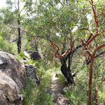
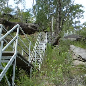
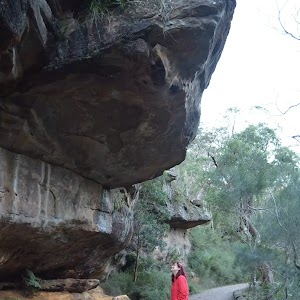
Veer left: From the intersection (on the western side of the causeway), this walk follows the somewhat over grown ‘Waterfall 7km’ arrow[2] on the ‘Bullawarring Track’ signpost, along the narrow track that initially heads up the hill away from the creek then bends left, keeping the valley to your left. The walk then follows this narrow track south, keeping Heathcote Creek down the hill to your left, as the track climbs up the side of the hill to flatten out high above the creek. From here, the track continues along the side of the ridge, with occasional views of the creek in the valley to the left, as the walk winds through thick bushland until coming to the signposted intersection of the ‘Goanna Track'[ref img=114136.
Continue straight: From the intersection, this walk follows the ‘Waterfall’ arrow on the Bullawarring Track signpost, winding along the bush track on the side of the hill for a long time, occasionally passing a rock platform with views of Heathcote Creek. The walk winds up and down a few steep rocky sections and crosses the dried-up creek in Python Gully. At this point, the track continues around the edge of the valley before descending quite steeply to Heathcote Creek, where it comes to the signposted intersection of the Mooray Track.
Continue straight: From the intersection, this walk follows the ‘Waterfall’ arrow on the Bullawarring Track signpost, winding along the bush track on the side of the hill for a long time, occasionally passing a rock platform with views of Heathcote Creek. The walk winds up and down a few steep rocky sections and crosses the dried-up creek in Python Gully. At this point, the track continues around the edge of the valley before descending quite steeply to Heathcote Creek, where it comes to the signposted intersection of the Mooray Track.
(7.58km) Int of Battery and Mooray Tracks → Kingfisher Pool camping ground
930 m
21 mins
48m
-32m
Moderate track
Continue straight: From the intersection, this walk follows the ‘Waterfall’ arrow on the Bullawarring Track signpost, heading along the bush track which follows Heathcote Creek. The track winds through the bush with small ups and downs, until it comes back down to the side of the creek, crossing at the rocks.
Continue straight: From the intersection, this walk follows the ‘Waterfall’ arrow on the ‘Mooray Track’ sign, heading down and across the creek at the rocks, following the painted track markers up the other side and along the bush track to a large open clearing. From here, the track follows the track marker though the clearing and along the bush track for a short while, coming to some large boulders. Here, the track turns right and then immediately left at the painted marker, climbing up onto the top of the rock platform. From the top of the platform, the walk follows the bush track, heading away from the creek for a short distance before turning left at the bush track and continuing to the Kingfisher Pool camping ground.
Continue straight: From the intersection, this walk follows the ‘Waterfall’ arrow on the ‘Mooray Track’ sign, heading down and across the creek at the rocks, following the painted track markers up the other side and along the bush track to a large open clearing. From here, the track follows the track marker though the clearing and along the bush track for a short while, coming to some large boulders. Here, the track turns right and then immediately left at the painted marker, climbing up onto the top of the rock platform. From the top of the platform, the walk follows the bush track, heading away from the creek for a short distance before turning left at the bush track and continuing to the Kingfisher Pool camping ground.
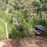
Kingfisher Pool camping ground
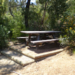
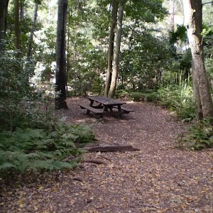
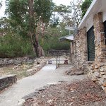
This campsite is located at a small clearing, just east of the junction of Heathcote and Kingfisher Creeks in Heathcote National Park. The campsite is above the creek on a flat clearing. The creek usually provides plenty of water (treat before use, and check with rangers before setting out) and an opportunity for a swim. At the campground, there is also a small pit toilet and picnic table. Open fires are not permitted, so bring your own fuel stove. Fees are payable in advance for the permit required to stay at this campsite.
End of day 1
This is the planned overnight stay for the end of day 1, happy camping.
(8.5km) Kingfisher Pool camping ground → Int of Heathcote Creek Bushtrail and Lake Toolooma Servicetrail
830 m
15 mins
15m
-15m
Moderate track
Continue straight: From the campsite, this walk heads away from the water for about 20m back to the main track, where this walk turns left to head east through the thick scrub for a while. There is an occasional view of the creek as the track heads along to a ‘Y’ intersection with another bush track that has been blocked off. Here, this walk turns left and continues along to the signposted intersection with a management trail.
(9.33km) Int of Lake Toolooma Servicetrail and Heathcote Creek Track → End of Warabin Rd
750 m
20 mins
88m
-3m
Moderate track
Turn left: From the intersection, this walk heads north, crossing the creek and heading along the service trail for a very short period, before coming to an intersection with a bush track going off to the right.
Turn right: From the intersection, this walk follows the ‘Bullawarring Track – Waterfall’ sign[3] south-east away from the power lines, following the narrow but clear track for several hundred metres (ignoring faint tracks to the left). The track then lends slightly to the left and heads up the hill to an intersection with a service trail.
Continue straight: From the intersection, this walk follows the narrow track and painted arrow[4] in the middle of the rock step, heading east up the rocky steps. The walk climbs up some rough rock steps with some carved foot-holes in the rock outcrop, to the top of some short cliffs. From here, the walk follows the rock platform at the top of the short cliffs, and the painted arrows, to the bush track which continues up the long rocky hill. The walk continues up a long set of wooden steps to the signposted intersection with a service trail.
Turn right: From the intersection, this walk follows the service trail, heading up the gentle hill towards the houses for a short while before coming to the end of Warabin Street.
(10.08km) End of Warabin Rd → Waterfall Station
730 m
14 mins
22m
-10m
Very easy
Veer right: From the end of Warabin St, this walk follows the road up the hill and past the intersection of Yanagang Street, continuing up to the next intersection. Here, the walk turns left into Koorabin St, then passes over the Princes Highway and comes to the Waterfall Station entry ramp.
Maps for the Heathcote to Waterfall Overnight Walk walk
You can download the PDF for this walk to print a map.
These maps below cover the walk and the wider area around the walk, they are worth carrying for safety reasons.
| Port Hacking | 1:25 000 Map Series | 91294N PORT HACKING | NSW-91294N |
| Appin | 1:25 000 Map Series | 90291S APPIN | NSW-90291S |
| Campbelltown | 1:25 000 Map Series | 90291N CAMPBELLTOWN | NSW-90291N |
| Campbelltown | 1:50 000 Map Series | 90291 CAMPBELLTOWN | CW-90291 |
| Port Hacking | 1:100 000 Map Series | 9129 PORT HACKING | 9129 |
| Wollongong | 1:100 000 Map Series | 9029 WOLLONGONG | 9029 |
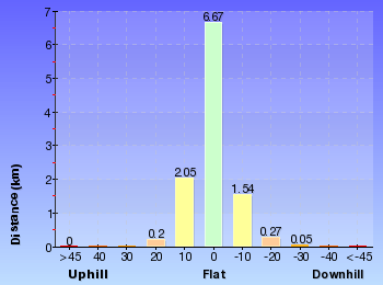
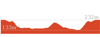
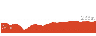
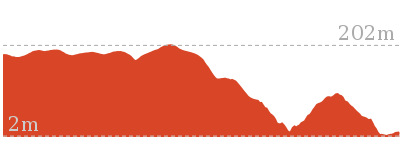
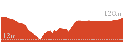
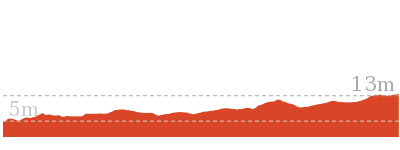
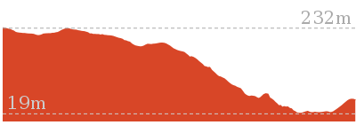
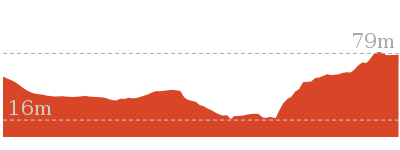
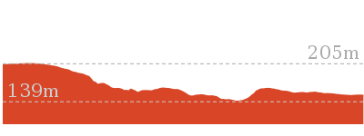
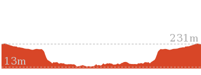
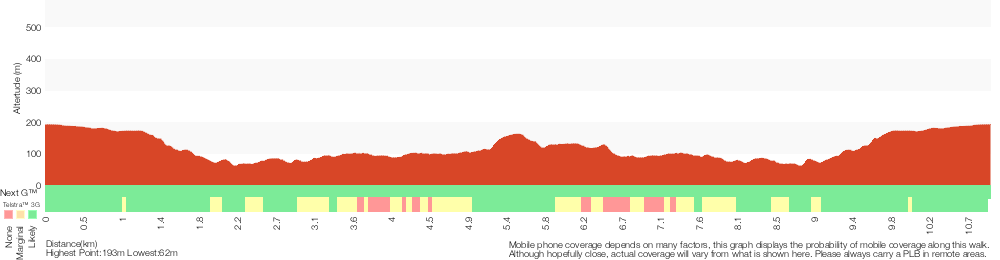
Cross sectional view of the Heathcote to Waterfall Overnight Walk bushwalking track
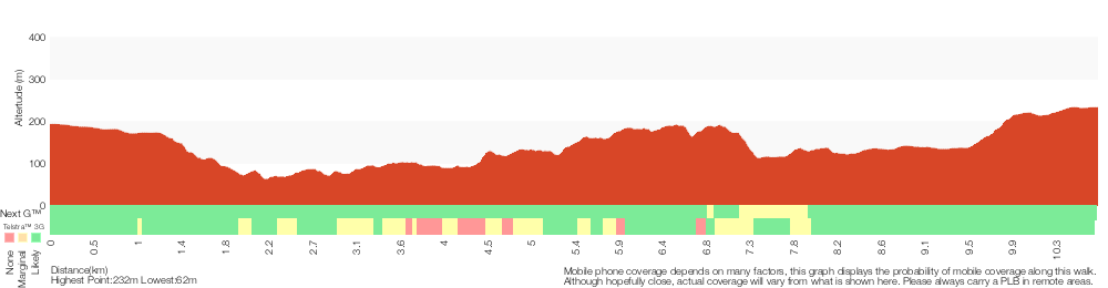
Analysis and summary of the altitude variation on the Heathcote to Waterfall Overnight Walk
Daily actual walking time estimates
| Day | Walking Time | Length |
|---|---|---|
| 1 | 3 hrs 17 mins | 9 km |
| 2 | 49 mins | 2.3 km |
Overview of this walks grade – based on the AS 2156.1 – 2001
Under this standard, a walk is graded based on the most difficult section of the walk.
| Length | 10.8 km | ||
| Time | 2 Days | ||
| . | |||
| Grade 4/6 Hard track |
AS 2156.1 | Gradient | Short steep hills (3/6) |
| Quality of track | Rough track, where fallen trees and other obstacles are likely (4/6) | ||
| Signs | Minimal directional signs (4/6) | ||
| Experience Required | Some bushwalking experience recommended (3/6) | ||
| Weather | Weather generally has little impact on safety (1/6) | ||
| Infrastructure | Limited facilities, not all cliffs are fenced (3/6) |
Some more details of this walks Grading
Here is a bit more details explaining grading looking at sections of the walk
Gradient
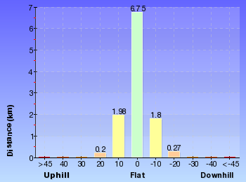
4.8km of this walk has gentle hills with occasional steps and another 3.6km has short steep hills. The remaining (2.3km) is flat with no steps.
Quality of track
3.9km of this walk follows a clear and well formed track or trail and another 3.8km follows a formed track, with some branches and other obstacles. Whilst another 1.8km follows a smooth and hardened path and the remaining 1.3km follows a rough track, where fallen trees and other obstacles are likely.
Signs
6km of this walk is clearly signposted and another 3.6km has directional signs at most intersection. The remaining (1.3km) has minimal directional signs.
Experience Required
Around 5km of this walk requires some bushwalking experience, whilst the remaining 5km requires no previous bushwalking experience.
weather
This whole walk, 11km is not usually affected by severe weather events (that would unexpectedly impact safety and navigation).
Infrastructure
Around 9km of this walk has limited facilities (such as not all cliffs fenced), whilst the remaining 2.3km is close to useful facilities (such as fenced cliffs and seats).
Similar walks
A list of walks that share part of the track with the Heathcote to Waterfall Overnight Walk walk.
6.4 km Circuit
2 hrs 30 mins
Moderate track
10.1 km One way
5 hrs
Hard track

10.8 km One way
5 hrs
Hard track

11 km Circuit
4 hrs
Hard track

Other Nearby walks
A list of walks that start near the Heathcote to Waterfall Overnight Walk walk.
10 km One way
4 hrs 15 mins
Hard track

15 km One way
6 hrs 30 mins
Hard track
11.3 km One way
4 hrs 30 mins
Hard track
5.6 km Return
3 hrs
Moderate track
5.8 km One way
2 hrs 30 mins
Hard track

858 m Return
20 mins
Easy track
5 km Return
1 hr 45 mins
Easy track

10.5 km Return
4 hrs
Moderate track

4.4 km One way
2 hrs
Hard track
2.3 km Circuit
1 hr 15 mins
Hard track

2.2 km Return
45 mins
Easy track
918 m Return
20 mins
Very easy
Plan your trip to and from the walk here
The Heathcote to Waterfall Overnight Walk walk starts at the Heathcote Railway Station (gps: -34.088189, 151.00809)
Your transport options to Heathcote Railway Station are by;
![]() Train. (get details)
Train. (get details)
![]() Car. There is free parking available.
Car. There is free parking available.
(get details)
![]() Train. (get details)
Train. (get details)
The Heathcote to Waterfall Overnight Walk ends at the Waterfall Station (gps: -34.135215, 150.99461)
Your main transport option to Waterfall Station is by;
![]() Car. There is free parking available.
Car. There is free parking available.
(get details)


Short URL = http://wild.tl/htwow
Gallery images
There are other downloads I am still working on.
You will probably need to login to access these — still all free.
* KML (google earth file)
* GPX (GPS file)
Special Maps/ brochures
* A3 topo maps
* PDF with Lands Topo map base
* PDF with arial image (and map overlay)
I wanted to get the main site live first, this extra stuff will come in time.
Happy walking
Matt 🙂
Waterfall to Heathcote
And Walk
Waterfall to Heathcote

5 hrs
10.8 km One way
467 m
Hard track
This walk explores the heart of Heathcote National Park, and is easily accessed with a train station at either end. Although relatively close to the start of the walk, Kingfisher Pool, next to Heathcote Creek, is a great spot to break and enjoy the park. Mirang Pool, at the northern end, also offers an opportunity to cool down before the last walk up the hill.


(0km) Waterfall Station → End of Warabin Rd
730 m
14 mins
10m
-22m
Very easy
From Waterfall Railway Station, this walk takes the ramp out of the station onto Kooraban St. The walk follows Kooraban St over the Princess Highway, then turns right into Warabin St. This is followed to the end, where it comes to the intersection with the service trail signposted as the ‘Bullawarring Track’.
(0.73km) End of Warabin Rd → Int of Bullawarring Track and Warabin Servicetrail
90 m
2 mins
0m
-4m
Easy track
Veer left: From the end of Warabin St, this walk passes the large National Park gate and the sign saying ‘Bullawarring Track – Heathcote National Park’, heading along the service trail for a short while before coming to the signposted intersection of the Bullawarring Track at the top of the long set of wooden stairs.
(0.82km) Int of Bullawarring Track and Warabin Servicetrail → Int of Bullawarring Track and Lake Toolooma Servicetrail
280 m
9 mins
0m
-52m
Moderate track
Turn left: From the intersection, this walk follows the ‘Bullawarring Trac Kingfisher Pool and Lake Eckersley’ sign[1] down to the bottom of a long set of wooden steps. From here, the walk continues down the hill along the rocky bush track to the top of some short cliffs, where the walk follows the rock shelf for a short distance before continuing steeply down the rocky slope and down the hill to the intersection of the Lake Toolooma service trail.
(1.1km) Int of Bullawarring Track and Lake Toolooma Servicetrail → Int of Waterfall Gully and Lake Toolooma Servicetrail (west)
340 m
8 mins
3m
-31m
Moderate track
Continue straight: From the intersection, this walk heads west down off the service trail and onto the bush track. Soon the track bends right and continues along the narrow, cleared track for several hundred metres until coming to an intersection with a service trail, signposted as part of the Bullawarring Track.
(1.44km) Int of Waterfall Gully and Lake Toolooma Servicetrail (west) → Int of Lake Toolooma Servicetrail and Heathcote Creek Track
30 m
1 mins
0m
-1m
Moderate track
Turn left : From the intersection, this walk heads south for a very short period before crossing the creek and going up slightly, and then comes to an intersection with a bush track going off to the right.
(1.48km) Int of Heathcote Creek Bushtrail and Lake Toolooma Servicetrail → Kingfisher Pool camping ground
830 m
15 mins
15m
-15m
Moderate track
Turn right: From the intersection, this walk follows the ‘Bullawarring Track’ signpost and the painted ‘Heathcote Kingfisher’ marker along the bush track, passing under the high-tension power lines and winding through the thick scrub, with the occasional view of the creek off to the right. This continues for a while before the track comes to an intersection with a 5m bush track on the right, leading to the Kingfisher Pool camping ground.
Kingfisher Pool camping ground
This campsite is located at a small clearing, just east of the junction of Heathcote and Kingfisher Creeks in Heathcote National Park. The campsite is above the creek on a flat clearing. The creek usually provides plenty of water (treat before use, and check with rangers before setting out) and an opportunity for a swim. At the campground, there is also a small pit toilet and picnic table. Open fires are not permitted, so bring your own fuel stove. Fees are payable in advance for the permit required to stay at this campsite.
(2.31km) Kingfisher Pool camping ground → Int of Bullawarring and Goanna Tracks
3.1 km
1 hr 13 mins
176m
-166m
Moderate track
Continue straight: From the campsite, this walk follows the bush track behind the fireplace for a short distance before turning right at the bush track and continuing along to the rock platform above Heathcote Creek. From here, the walk turns left and follows the bush track, keeping the creek down to the right as the track drops down a short, steep rock surface. The walk turns right, following the bush track that the winds through the bush for a short while to a large open clearing. From the clearing, the track follows the track marker on the other side through the bush and down to the creek, which it crosses at the rocks and comes up to the signposted intersection of the ‘Bullawarring Track’.
Continue straight: From the intersection, this walk follows the bush track, heading north along the left-hand side of the creek. The track gradually rises up above the rock shelves lining the creek, and continues along through the bush for a while before the track comes back down to the signposted intersection of the ‘Battery Causeway’ track.
Continue straight: From the intersection, this walk follows the ‘Battery Causeway’ arrow on the Bullawarring Track signpost, heading along the bush track which steadily climbs up the side of the valley for a while before crossing the dried-up creek at Python Gully. From here, the track continues along the side of the valley, climbing up the side of the hill for a while before flattening out again high above Heathcote Creek – this can be seen from the occasional rock shelf on the side of the track. The walk winds along to the signposted intersection of the Goanna Track.
(5.43km) Int of Bullawarring and Goanna Tracks → Battery Causeway
1.3 km
30 mins
49m
-100m
Hard track
Continue straight: From the intersection, this walk follows the ‘Pipeline Rd 1.0km’ arrow on the ‘Bullawarring Track’ signpost[2], heading along the bush track which follows the side of the hill. The rocky bush track winds up and down through the thick bushland, with occasional views of Heathcote Creek down to the right. This continues for a while until the track drops steeply down a short rocky section and continues down the hill to the signposted intersection of the service trail at the Battery Causeway.
(6.75km) Battery Causeway → Int of Pipeline Track and Mirang Rd Servicetrail
1 km
21 mins
32m
-46m
Moderate track
Veer right: From the intersection, the walk crosses the creek using concrete Battery Causeway and follows the management trail up the gentle hill, past a picnic table to soon cross the pipeline on a timber bridge. From here, the walk continues along the management trail, keeping the pipeline on the right for 750m until the trail bends left away from the pipeline and onto an asphalt surface. The trail winds down a hill to the intersection of the Mirang Road service trail.
Mirang Pool camping ground
This campsite is nestled in Heathcote National Park, with walk-in access from Heathcote Station. The campsite is near Mirang Pool on Heathcote Creek – there is a signpost at the top of the stairs, leading down to the pools from the management trail above. There are no facilities provided at the campsite, and you will need to carry in your own water and fuel stove.
(7.77km) Int of Pipeline Track and Mirang Rd Servicetrail → Int. of Mirang Track and Friendly Tracks
1.3 km
29 mins
74m
-56m
Moderate track
Continue straight: From the intersection, the walk follows the asphalt management trail down the hill and through a gate, doing a large ‘S’ bend and crossing the pipeline twice. The surface of the trail changes to dirt and the walk continues, with Heathcote Creek on the left, to the signposted intersection with the Mirang Pool track.
Continue straight: From the intersection, this walk follows the management trail in the unsignposted direction, keeping the pipeline on the right and Heathcote Creek down the hill on the left. The walk heads along until it crosses a bridge onto an asphalt surface and heads up the long hill that winds to the intersection with another trail, opposite the metal platform crossing the pipeline.
Continue straight: From the intersection, this walk follows the management trail in the unsignposted direction, keeping the pipeline on the right and Heathcote Creek down the hill on the left. The walk heads along until it crosses a bridge onto an asphalt surface and heads up the long hill that winds to the intersection with another trail, opposite the metal platform crossing the pipeline.
(9.05km) Int. of Mirang Track and Friendly Tracks → End of Freeman Road service trail
420 m
10 mins
60m
-5m
Moderate track
Continue straight: From the intersection, the walk heads up and over the large concrete pipeline at the metal platform and stairs. The track then continues up the long hill for a while before coming to an intersection with a rough track (heading up on the left, about 40 metres before the high tension power lines).
Turn left: From the intersection, the walk follows the rough bush track heading up the side of the hill, climbing steeply up along the sometimes-faint path. The track soon flattens out and bends around to the right, passing a burnt-out car shell before coming an the intersection with a management trail.
Turn left: From the intersection, the walk follows the rough bush track heading up the side of the hill, climbing steeply up along the sometimes-faint path. The track soon flattens out and bends around to the right, passing a burnt-out car shell before coming an the intersection with a management trail.
(9.47km) Freeman Rd and Friendly Track Int → End of Freeman Rd
310 m
6 mins
24m
-1m
Moderate track
Turn left: From the intersection, the walk follows the management trail up the long hill. The walk passes a trail on the right and flattens out a little, continuing up and around to the right. This walk passes another management trail (heading behind some houses) as it flattens out more and crosses under the power lines to the road.
(9.78km) End of Freeman Rd → Heathcote Railway Station
1 km
17 mins
24m
-4m
Very easy
Veer right: From the intersection, this walk follows Freemans Road all the way past the large scout camp facility, to the intersection of Boundary Road, where it turns left and continues along for a short distance to the intersection of Oliver Street. From here, this walk turns right onto Oliver Street, which it follows to the end, meeting the Princes Highway. From here, the track crosses the highway at the traffic lights and continues along the footpath, with the car park to the left, coming to the train station.
Maps for the Waterfall to Heathcote walk
You can download the PDF for this walk to print a map.
These maps below cover the walk and the wider area around the walk, they are worth carrying for safety reasons.
| Port Hacking | 1:25 000 Map Series | 91294N PORT HACKING | NSW-91294N |
| Appin | 1:25 000 Map Series | 90291S APPIN | NSW-90291S |
| Campbelltown | 1:25 000 Map Series | 90291N CAMPBELLTOWN | NSW-90291N |
| Campbelltown | 1:50 000 Map Series | 90291 CAMPBELLTOWN | CW-90291 |
| Port Hacking | 1:100 000 Map Series | 9129 PORT HACKING | 9129 |
| Wollongong | 1:100 000 Map Series | 9029 WOLLONGONG | 9029 |
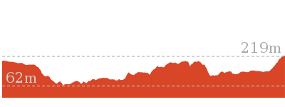
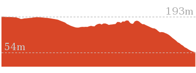
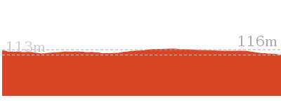
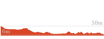
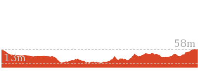
Cross sectional view of the Waterfall to Heathcote bushwalking track
Analysis and summary of the altitude variation on the Waterfall to Heathcote
Overview of this walks grade – based on the AS 2156.1 – 2001
Under this standard, a walk is graded based on the most difficult section of the walk.
| Length | 10.8 km | ||
| Time | 5 hrs | ||
| . | |||
| Grade 4/6 Hard track |
AS 2156.1 | Gradient | Short steep hills (3/6) |
| Quality of track | Rough track, where fallen trees and other obstacles are likely (4/6) | ||
| Signs | Minimal directional signs (4/6) | ||
| Experience Required | Some bushwalking experience recommended (3/6) | ||
| Weather | Weather generally has little impact on safety (1/6) | ||
| Infrastructure | Limited facilities, not all cliffs are fenced (3/6) |
Some more details of this walks Grading
Here is a bit more details explaining grading looking at sections of the walk
Gradient
4.8km of this walk has gentle hills with occasional steps and another 3.6km has short steep hills. The remaining (2.3km) is flat with no steps.
Quality of track
3.9km of this walk follows a clear and well formed track or trail and another 3.8km follows a formed track, with some branches and other obstacles. Whilst another 1.8km follows a smooth and hardened path and the remaining 1.3km follows a rough track, where fallen trees and other obstacles are likely.
Signs
6km of this walk is clearly signposted and another 3.6km has directional signs at most intersection. The remaining (1.3km) has minimal directional signs.
Experience Required
Around 5km of this walk requires some bushwalking experience, whilst the remaining 5km requires no previous bushwalking experience.
weather
This whole walk, 11km is not usually affected by severe weather events (that would unexpectedly impact safety and navigation).
Infrastructure
Around 9km of this walk has limited facilities (such as not all cliffs fenced), whilst the remaining 2.3km is close to useful facilities (such as fenced cliffs and seats).
Similar walks
A list of walks that share part of the track with the Waterfall to Heathcote walk.
6.4 km Circuit
2 hrs 30 mins
Moderate track
10.1 km One way
5 hrs
Hard track
10.8 km One way
2 Days
Hard track

11 km Circuit
4 hrs
Hard track
Other Nearby walks
A list of walks that start near the Waterfall to Heathcote walk.
9.8 km Return
4 hrs 30 mins
Hard track
8.9 km Return
3 hrs 30 mins
Moderate track
9.7 km One way
3 hrs 45 mins
Moderate track
5.1 km Return
2 hrs
Hard track
4.4 km Circuit
1 hr 45 mins
Moderate track
4.1 km One way
1 hr 30 mins
Moderate track
4.7 km One way
1 hr 45 mins
Moderate track

11.8 km Return
4 hrs 30 mins
Hard track

12.5 km Circuit
4 hrs 30 mins
Moderate track
10 km One way
4 hrs 15 mins
Hard track
15 km One way
6 hrs 30 mins
Hard track
11.3 km One way
4 hrs 30 mins
Hard track
Plan your trip to and from the walk here
The Waterfall to Heathcote walk starts at the Waterfall Station (gps: -34.135215, 150.99461)
Your transport options to Waterfall Station are by;
![]() Train. (get details)
Train. (get details)
![]() Bus. (get details)
Bus. (get details)
![]() Car. There is free parking available.
Car. There is free parking available.
(get details)
![]() Train. (get details)
Train. (get details)
The Waterfall to Heathcote ends at the Heathcote Railway Station (gps: -34.088189, 151.00809)
Your transport options to Heathcote Railway Station are by;
![]() Bus. (get details)
Bus. (get details)
![]() Car. There is free parking available.
Car. There is free parking available.
(get details)
Short URL = http://wild.tl/wth
Gallery images
There are other downloads I am still working on.
You will probably need to login to access these — still all free.
* KML (google earth file)
* GPX (GPS file)
Special Maps/ brochures
* A3 topo maps
* PDF with Lands Topo map base
* PDF with arial image (and map overlay)
I wanted to get the main site live first, this extra stuff will come in time.
Happy walking
Matt 🙂
The Goanna Track Circuit
And Walk
The Goanna Track Circuit

4 hrs
11 km Circuit
484 m
Hard track
The Goanna Track is a short but pleasant bush track with some good views down over Heathcote Creek. Mostly along management trail, this walk follows the pipeline from Heathcote out to the Goanna Track circuit. Be sure to go down to Lake Eckersley as this is arguably the prettiest part of the walk. If wanting a break, there are some good spots down at water level, with nice views and picnic tables.


(0km) Heathcote Railway Station → End of Freeman Rd
1 km
17 mins
4m
-24m
Very easy
From the station, this walk follows the footpath towards the highway, passing the left side of the car park, until it reaches the highway, which it crosses at the traffic lights. The walk continues along Oliver Street for a while before coming to the intersection with Boundary Road. Here, this walk turns left, following the road for a short distance before taking the first right onto Freemans Road and continuing past the large scout camp, to the end of the road, where it comes to the intersection with the management trail at the corner of Bella Vista Street.
(1.03km) End of Freeman Rd → Int of Scout Camp and Freeman Road bushtracks
400 m
9 mins
2m
-47m
Moderate track
Veer left: From the intersection, this walk follows the management trail, crossing under the high tension power lines and bending around to the right a short distance, before coming back around to the left and passing a management trail (which heads behind some houses). The walk continues down the hill, passing another trail on the left as the hill steepens and comes to an intersection with a rough bush track, opposite the power line tower at the bottom of the trail.
Turn right: From the intersection, the walk follows the bush track on the opposite side of the management trail to the power line tower. The walk passes a burnt-out car shell before turning down the long steep hill and winding down to the ‘T’ intersection with a wider track.
Turn right: From the intersection, the walk follows the bush track on the opposite side of the management trail to the power line tower. The walk passes a burnt-out car shell before turning down the long steep hill and winding down to the ‘T’ intersection with a wider track.
(1.43km) Int of Scout Camp and Freeman Road bushtracks → Int. of Mirang Track and Friendly Tracks
330 m
7 mins
4m
-37m
Moderate track
Turn right: From the intersection, the walk follows the track heading down along the side of the hill and through the thick bush. After a short while, the track comes to a large concrete pipeline, crossing it at the metal platform to the intersection with the management trail.
(1.76km) Int. of Mirang Track and Friendly Tracks → Int. of Mirang and Mirang Pool Tracks
940 m
21 mins
43m
-50m
Moderate track
Continue straight: From the intersection, this walk follows the ‘Mirang Pool’ arrow along the asphalt trail down the long hill. After a short while, the trail bends around to the left, turning back towards the pipeline, and continues downhill until it flattens out and crosses a bridge at the pipeline. From here, the walk continues along the management trail, following the pipeline (with Heathcote Creek down the hill on the right) for a while before coming to the signposted intersection with the Mirang Pool track.
Mirang Pool camping ground
This campsite is nestled in Heathcote National Park, with walk-in access from Heathcote Station. The campsite is near Mirang Pool on Heathcote Creek – there is a signpost at the top of the stairs, leading down to the pools from the management trail above. There are no facilities provided at the campsite, and you will need to carry in your own water and fuel stove.
(2.7km) Int. of Mirang and Mirang Pool Tracks → Int of Pipeline Track and Mirang Rd Servicetrail
340 m
8 mins
13m
-24m
Moderate track
Continue straight: From the intersection, this walk follows the ‘Lake Eckersley’ arrow along the management trail, keeping the pipe line to the left, as it heads through the bush. After a while, the trail does a large ‘S’ bend, crossing the pipeline twice as before passing through a gate and up to the intersection with the Mirang Road service trail.
(3.04km) Int of Pipeline Track and Mirang Rd Servicetrail → Battery Causeway
1 km
21 mins
46m
-32m
Moderate track
Continue straight: From the intersection, the walk follows the asphalt management trail, keeping Heathcote Creek and the valley to the right as the trail rounds a bend and heads up run parallel with the pipeline as the trail becomes gravel. From here, the walk continues along the management trail, keeping the pipeline on the left for about 750m. The walk then crosses over the pipeline using a timber bridge and 160m further along the management trail the walk passes a picnic table and crosses Heathcote Creek at the concrete Battery Causeway. (Here you may notice the ‘Bullawarring Track – Waterfall 7km’ sign[1] up to your left).
(4.06km) Battery Causeway → Int of Lake Eckersley and Pipeline Tracks
290 m
6 mins
14m
-1m
Moderate track
Veer right: From the intersection, this walk follows the management trail, heading up the hill with the creek down to the right. The trail does a sharp ‘U’ turn to the left, and continues up the hill to the signposted intersection of the ‘Lake Eckersley Track’.
(4.34km) Int of Lake Eckersley and Pipeline Tracks → Lake Eckersley
220 m
5 mins
0m
-41m
Moderate track
Turn right: From the intersection, this walk follows the bush track beside the signpost, heading down through the bush and away from the pipeline. As the track winds down the hill, it bends around to the left, winding through the dense scrub for a short while before bending back to the right and continuing down the rocky path to the edge of Woronora River. At the end of this side trip, retrace your steps back to the main walk then Turn right.
(4.34km) Int of Lake Eckersley and Pipeline Tracks → Int of Pipeline and Goanna Tracks
840 m
19 mins
46m
-34m
Moderate track
Continue straight: From the intersection, this walk follows the management trail, keeping the pipeline on the left and providing the occasional view over the valley and creek to the right. This continues for a while until reaching a signposted intersection with the ‘Goanna Track’ (which goes up over the pipeline on a metal bridge).
(5.18km) Int of Pipeline and Goanna Tracks → Int of Goanna Track and the Pipeline bushtrack
300 m
9 mins
49m
0m
Moderate track
Turn left: From the intersection, the walk follows the ‘Goanna Track’ signpost[2] over the pipeline at the metal platform. The rough track climbs up the rocky hill for a while before flattening out and coming to a signpost and the intersection with the pipeline track.
(5.48km) Int of Goanna Track and the Pipeline bushtrack → Int of Goanna and Bullawarring Tracks
160 m
3 mins
0m
-23m
Moderate track
Continue straight: From the intersection, this walk follows the left-hand arrow on the signpost, south along the side of the hill. Soon, the track turns down the hill to the signposted intersection with the ‘Bullawarring Track’[3].
(5.64km) Int of Bullawarring and Goanna Tracks → Int. of Mirang Track and Friendly Tracks
3.6 km
1 hr 20 mins
155m
-202m
Hard track
Turn left: From the intersection, this walk follows the ‘Pipeline Rd 1.0km’ arrow on the ‘Bullawarring Track’ signpost[4], heading along the bush track which follows the side of the hill. The rocky bush track winds up and down through the thick bushland, with occasional views of Heathcote Creek down to the right. This continues for a while until the track drops steeply down a short rocky section and continues down the hill to the signposted intersection of the service trail at the Battery Causeway.
Veer right: From the intersection, the walk crosses the creek using concrete Battery Causeway and follows the management trail up the gentle hill, past a picnic table to soon cross the pipeline on a timber bridge. From here, the walk continues along the management trail, keeping the pipeline on the right for 750m until the trail bends left away from the pipeline and onto an asphalt surface. The trail winds down a hill to the intersection of the Mirang Road service trail.
Continue straight: From the intersection, the walk follows the asphalt management trail down the hill and through a gate, doing a large ‘S’ bend and crossing the pipeline twice. The surface of the trail changes to dirt and the walk continues, with Heathcote Creek on the left, to the signposted intersection with the Mirang Pool track.
Continue straight: From the intersection, this walk follows the management trail in the unsignposted direction, keeping the pipeline on the right and Heathcote Creek down the hill on the left. The walk heads along until it crosses a bridge onto an asphalt surface and heads up the long hill that winds to the intersection with another trail, opposite the metal platform crossing the pipeline.
(9.26km) Int. of Mirang Track and Friendly Tracks → Heathcote Railway Station
1.8 km
33 mins
108m
-10m
Moderate track
Continue straight: From the intersection, the walk heads up and over the large concrete pipeline at the metal platform and stairs. The track then continues up the long hill for a while before coming to an intersection with a rough track (heading up on the left, about 40 metres before the high tension power lines).
Turn left: From the intersection, the walk follows the rough bush track heading up the side of the hill, climbing steeply up along the sometimes-faint path. The track soon flattens out and bends around to the right, passing a burnt-out car shell before coming an the intersection with a management trail.
Turn left: From the intersection, the walk follows the management trail up the long hill. The walk passes a trail on the right and flattens out a little, continuing up and around to the right. This walk passes another management trail (heading behind some houses) as it flattens out more and crosses under the power lines to the road.
Veer right: From the intersection, this walk follows Freemans Road all the way past the large scout camp facility, to the intersection of Boundary Road, where it turns left and continues along for a short distance to the intersection of Oliver Street. From here, this walk turns right onto Oliver Street, which it follows to the end, meeting the Princes Highway. From here, the track crosses the highway at the traffic lights and continues along the footpath, with the car park to the left, coming to the train station.
Maps for the The Goanna Track Circuit walk
You can download the PDF for this walk to print a map.
These maps below cover the walk and the wider area around the walk, they are worth carrying for safety reasons.
| Port Hacking | 1:25 000 Map Series | 91294N PORT HACKING | NSW-91294N |
| Campbelltown | 1:25 000 Map Series | 90291N CAMPBELLTOWN | NSW-90291N |
| Campbelltown | 1:50 000 Map Series | 90291 CAMPBELLTOWN | CW-90291 |
| Port Hacking | 1:100 000 Map Series | 9129 PORT HACKING | 9129 |
| Wollongong | 1:100 000 Map Series | 9029 WOLLONGONG | 9029 |
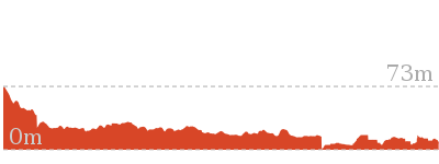
Cross sectional view of the The Goanna Track Circuit bushwalking track
Analysis and summary of the altitude variation on the The Goanna Track Circuit
Overview of this walks grade – based on the AS 2156.1 – 2001
Under this standard, a walk is graded based on the most difficult section of the walk.
| Length | 11 km | ||
| Time | 4 hrs | ||
| . | |||
| Grade 4/6 Hard track |
AS 2156.1 | Gradient | Short steep hills (3/6) |
| Quality of track | Rough track, where fallen trees and other obstacles are likely (4/6) | ||
| Signs | Minimal directional signs (4/6) | ||
| Experience Required | Some bushwalking experience recommended (3/6) | ||
| Weather | Weather generally has little impact on safety (1/6) | ||
| Infrastructure | Limited facilities, not all cliffs are fenced (3/6) |
Some more details of this walks Grading
Here is a bit more details explaining grading looking at sections of the walk
Gradient
8km of this walk has gentle hills with occasional steps and another 2.1km is flat with no steps. The remaining (1.2km) has short steep hills.
Quality of track
7km of this walk follows a clear and well formed track or trail and another 2.1km follows a smooth and hardened path. Whilst another 1.3km follows a rough track, where fallen trees and other obstacles are likely and the remaining 640m follows a formed track, with some branches and other obstacles.
Signs
9km of this walk is clearly signposted and another 1.3km has minimal directional signs. The remaining (840m) has directional signs at most intersection.
Experience Required
Around 10km of this walk requires no previous bushwalking experience, whilst the remaining 1.5km requires some bushwalking experience.
weather
This whole walk, 11km is not usually affected by severe weather events (that would unexpectedly impact safety and navigation).
Infrastructure
Around 8km of this walk has limited facilities (such as not all cliffs fenced), whilst the remaining 3.2km is close to useful facilities (such as fenced cliffs and seats).
Similar walks
A list of walks that share part of the track with the The Goanna Track Circuit walk.
10.1 km One way
5 hrs
Hard track
10.8 km One way
2 Days
Hard track
10.8 km One way
5 hrs
Hard track
Other Nearby walks
A list of walks that start near the The Goanna Track Circuit walk.
10 km One way
4 hrs 15 mins
Hard track
15 km One way
6 hrs 30 mins
Hard track
11.3 km One way
4 hrs 30 mins
Hard track
5.6 km Return
3 hrs
Moderate track
5.8 km One way
2 hrs 30 mins
Hard track
858 m Return
20 mins
Easy track
5 km Return
1 hr 45 mins
Easy track
10.5 km Return
4 hrs
Moderate track
4.4 km One way
2 hrs
Hard track
2.3 km Circuit
1 hr 15 mins
Hard track
2.2 km Return
45 mins
Easy track
918 m Return
20 mins
Very easy
Plan your trip to and from the walk here
The The Goanna Track Circuit walk starts and ends at the Heathcote Railway Station (gps: -34.088189, 151.00809)
Your transport options to Heathcote Railway Station are by;
![]() Train. (get details)
Train. (get details)
![]() Car. There is free parking available.
Car. There is free parking available.
(get details)
Short URL = http://wild.tl/tgtc
Gallery images
There are other downloads I am still working on.
You will probably need to login to access these — still all free.
* KML (google earth file)
* GPX (GPS file)
Special Maps/ brochures
* A3 topo maps
* PDF with Lands Topo map base
* PDF with arial image (and map overlay)
I wanted to get the main site live first, this extra stuff will come in time.
Happy walking
Matt 🙂
Lake Toolooma Trail
And Walk
Lake Toolooma Trail

2 hrs 30 mins
6.4 km Circuit
220 m
Moderate track


(0km) Waterfall Station → End of Warabin Rd
730 m
14 mins
10m
-22m
Very easy
From Waterfall Railway Station, this walk takes the ramp out of the station onto Kooraban St. The walk follows Kooraban St over the Princess Highway, then turns right into Warabin St. This is followed to the end, where it comes to the intersection with the service trail signposted as the ‘Bullawarring Track’.
(0.73km) End of Warabin Rd → Int of Bullawarring Track and Warabin Servicetrail
90 m
2 mins
0m
-4m
Easy track
Veer left: From the end of Warabin St, this walk passes the large National Park gate and the sign saying ‘Bullawarring Track – Heathcote National Park’, heading along the service trail for a short while before coming to the signposted intersection of the Bullawarring Track at the top of the long set of wooden stairs.
(0.82km) Int of Bullawarring Track and Warabin Servicetrail → Int of Bullawarring Track and Lake Toolooma Servicetrail
280 m
9 mins
0m
-52m
Moderate track
Turn left: From the intersection, this walk follows the ‘Bullawarring Trac Kingfisher Pool and Lake Eckersley’ sign[1] down to the bottom of a long set of wooden steps. From here, the walk continues down the hill along the rocky bush track to the top of some short cliffs, where the walk follows the rock shelf for a short distance before continuing steeply down the rocky slope and down the hill to the intersection of the Lake Toolooma service trail.
(1.1km) Int of Bullawarring Track and Lake Toolooma Servicetrail → Int of Lake Toolooma service trail and Toolooma Dam bushtrack
660 m
13 mins
11m
-22m
Unknow grade
Turn left : From the intersection, the walk follows the management trail south, keeping the bottom of the valley down to the right. The trail winds along for a while before coming to the intersection with a faint track (downhill on the right, towards the dam wall which is visible from the trail).
(1.76km) Int of Lake Toolooma service trail and Toolooma Dam bushtrack → Lake Toolooma dam wall
30 m
1 mins
0m
-5m
Moderate track
Veer right: From the intersection, the walk follows the track down the short, steep hill towards the lake and bends around to the right, winding through the bush to the end of the dam wall. At the end of this side trip, retrace your steps back to the main walk then Turn sharp right.
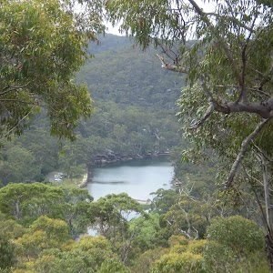
Lake Toolooma
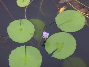
Lake Toolooma is a picturesque and well-hidden dam in the Heathcote National Park, just a stone’s throw from Waterfall and the Camp Coutts Scout Facility. This lake is best enjoyed from the end of the dam wall, near the lily pads.
(1.76km) Int of Lake Toolooma service trail and Toolooma Dam bushtrack → Int of Camp Coutts driveway and Lake Toolooma service trail
490 m
9 mins
14m
-15m
Moderate track
Continue straight: From here, this walk follows the management trail, keeping Lake Toolooma on the right as it heads through the bush. At the end of the lake, the trail bends to the left and continues along to the intersection with the asphalt management trail.
(2.24km) Int of Camp Coutts Driveway and Lake Toolooma service trail → Coutts Creek Scout Facility
510 m
9 mins
8m
-9m
Moderate track
Turn right: From the intersection, this walk follows the asphalt management trail west, down the gentle slope and through the bush to the Camp Coutts car park. From the car park, the walk heads through the large scout camp gate (‘Stan Bales Gateway’[2]) and along the driveway entrance, as the trail winds around the right-hand side of the scout camp buildings. The walk passes a toilet block and comes to an intersection with a management trail (which heads down and across the creek).
(2.76km) Coutts Creek Scout Facility → Int of Lake Toolooma service trail and Camp Couts service trail
320 m
6 mins
11m
-5m
Easy track
Veer right: From the Camp Couts Scout camp, the walk follows the management trail down across the creek and back up the other side, passing a large, flat, grassy clearing on the left. The walk continues through the bush, passing some of the scout camp’s picnic areas and comes to the intersection with another management trail.
(3.07km) Int of Lake Toolooma service trail and Camp Couts service trail → Int of Waterfall Gully and Lake Toolooma Servicetrail (west)
1.9 km
40 mins
57m
-80m
Moderate track
Turn sharp right: From the intersection, this walk follows the management trail up the hill. The trail soon steepens as it winds up the long hill to the rock platform at the top. Here, the trail bends to the right and continues along the ridge to the intersection with the Mt Westmacot track, just before the National Park gate.
Continue straight: From the intersection, the walk follows the management trail through the National Park gate and along the ridge, keeping the valley down to the right. The trail winds along beside the high tension power lines for a while before starting down the long and gradual hill. At the bottom of the valley,the walk comes to the signposted intersection with the ‘Bullawarring Track’[3] on the left (a short distance before the creek crossing).
Continue straight: From the intersection, this walk heads north, crossing the creek and heading along the service trail for a very short period, before coming to an intersection with a bush track going off to the right.
(4.98km) Int of Waterfall Gully and Lake Toolooma Servicetrail (west) → Int of Bullawarring Track and Lake Toolooma Servicetrail
340 m
8 mins
31m
-3m
Moderate track
Turn right: From the intersection, this walk follows the ‘Bullawarring Track – Waterfall’ sign[4] south-east away from the power lines, following the narrow but clear track for several hundred metres (ignoring faint tracks to the left). The track then lends slightly to the left and heads up the hill to an intersection with a service trail.
(5.33km) Int of Bullawarring Track and Lake Toolooma Servicetrail → Int of Bullawarring Track and Warabin Servicetrail
280 m
9 mins
52m
0m
Moderate track
Continue straight: From the intersection, this walk follows the narrow track and painted arrow[5] in the middle of the rock step, heading east up the rocky steps. The walk climbs up some rough rock steps with some carved foot-holes in the rock outcrop, to the top of some short cliffs. From here, the walk follows the rock platform at the top of the short cliffs, and the painted arrows, to the bush track which continues up the long rocky hill. The walk continues up a long set of wooden steps to the signposted intersection with a service trail.
(5.61km) Int of Bullawarring Track and Warabin Servicetrail → End of Warabin Rd
90 m
2 mins
4m
0m
Easy track
Turn right: From the intersection, this walk follows the service trail, heading up the gentle hill towards the houses for a short while before coming to the end of Warabin Street.
(5.7km) End of Warabin Rd → Waterfall Station
730 m
14 mins
22m
-10m
Very easy
Veer right: From the end of Warabin St, this walk follows the road up the hill and past the intersection of Yanagang Street, continuing up to the next intersection. Here, the walk turns left into Koorabin St, then passes over the Princes Highway and comes to the Waterfall Station entry ramp.
Maps for the Lake Toolooma Trail walk
You can download the PDF for this walk to print a map.
These maps below cover the walk and the wider area around the walk, they are worth carrying for safety reasons.
| Appin | 1:25 000 Map Series | 90291S APPIN | NSW-90291S |
| Campbelltown | 1:50 000 Map Series | 90291 CAMPBELLTOWN | CW-90291 |
| Wollongong | 1:100 000 Map Series | 9029 WOLLONGONG | 9029 |
Cross sectional view of the Lake Toolooma Trail bushwalking track
Analysis and summary of the altitude variation on the Lake Toolooma Trail
Overview of this walks grade – based on the AS 2156.1 – 2001
Under this standard, a walk is graded based on the most difficult section of the walk.
| Length | 6.4 km | ||
| Time | 2 hrs 30 mins | ||
| . | |||
| Grade 3/6 Moderate track |
AS 2156.1 | Gradient | Short steep hills (3/6) |
| Quality of track | Clear and well formed track or trail (2/6) | ||
| Signs | Directional signs along the way (3/6) | ||
| Experience Required | Some bushwalking experience recommended (3/6) | ||
| Weather | Weather generally has little impact on safety (1/6) | ||
| Infrastructure | Limited facilities, not all cliffs are fenced (3/6) |
Some more details of this walks Grading
Here is a bit more details explaining grading looking at sections of the walk
Gradient
2.4km of this walk has short steep hills and another 2.3km is flat with no steps. The remaining (990m) has gentle hills with occasional steps.
Quality of track
Around 4.3km of this walk follows a clear and well formed track or trail, whilst the remaining 1.5km follows a smooth and hardened path.
Signs
Around 3km of this walk has directional signs at most intersection, whilst the remaining 2.7km is clearly signposted.
Experience Required
Around 5km of this walk requires no previous bushwalking experience, whilst the remaining About 10m .
weather
This whole walk, 6km is not usually affected by severe weather events (that would unexpectedly impact safety and navigation).
Infrastructure
Around 3.4km of this walk is close to useful facilities (such as fenced cliffs and seats), whilst the remaining 2.3km has limited facilities (such as not all cliffs fenced).
Similar walks
A list of walks that share part of the track with the Lake Toolooma Trail walk.
10.1 km One way
5 hrs
Hard track
10.8 km One way
2 Days
Hard track
10.8 km One way
5 hrs
Hard track
Other Nearby walks
A list of walks that start near the Lake Toolooma Trail walk.
9.8 km Return
4 hrs 30 mins
Hard track
8.9 km Return
3 hrs 30 mins
Moderate track
9.7 km One way
3 hrs 45 mins
Moderate track
5.1 km Return
2 hrs
Hard track
4.4 km Circuit
1 hr 45 mins
Moderate track
4.1 km One way
1 hr 30 mins
Moderate track
4.7 km One way
1 hr 45 mins
Moderate track
11.8 km Return
4 hrs 30 mins
Hard track
12.5 km Circuit
4 hrs 30 mins
Moderate track
11 km Circuit
4 hrs
Hard track
10 km One way
4 hrs 15 mins
Hard track
15 km One way
6 hrs 30 mins
Hard track
Plan your trip to and from the walk here
The Lake Toolooma Trail walk starts and ends at the Waterfall Station (gps: -34.135215, 150.99461)
Your transport options to Waterfall Station are by;
![]() Train. (get details)
Train. (get details)
![]() Bus. (get details)
Bus. (get details)
![]() Car. There is free parking available.
Car. There is free parking available.
(get details)
Short URL = http://wild.tl/ltt
Gallery images
There are other downloads I am still working on.
You will probably need to login to access these — still all free.
* KML (google earth file)
* GPX (GPS file)
Special Maps/ brochures
* A3 topo maps
* PDF with Lands Topo map base
* PDF with arial image (and map overlay)
I wanted to get the main site live first, this extra stuff will come in time.
Happy walking
Matt 🙂
Heathcote to Waterfall
And Walk
Heathcote to Waterfall

5 hrs
10.1 km One way
481 m
Hard track
Spanning between Heathcote and Waterfall Railway Stations, this walk experiences many of the different environments that Heathcote National Park has to offer. From ridge tops to creek walking, this is a great way to enjoy a day, with a perfect spot for a break at the Heathcote Campsite. If the water’s deep enough, also allow enough time to dip your toes in Heathcote Creek.

(0km) Heathcote Railway Station → End of Freeman Rd
1 km
17 mins
4m
-24m
Very easy
From the station, this walk follows the footpath towards the highway, passing the left side of the car park, until it reaches the highway, which it crosses at the traffic lights. The walk continues along Oliver Street for a while before coming to the intersection with Boundary Road. Here, this walk turns left, following the road for a short distance before taking the first right onto Freemans Road and continuing past the large scout camp, to the end of the road, where it comes to the intersection with the management trail at the corner of Bella Vista Street.
(1.03km) End of Freeman Rd → Int of Scout Camp and Freeman Road bushtracks
400 m
9 mins
2m
-47m
Moderate track
Veer left: From the intersection, this walk follows the management trail, crossing under the high tension power lines and bending around to the right a short distance, before coming back around to the left and passing a management trail (which heads behind some houses). The walk continues down the hill, passing another trail on the left as the hill steepens and comes to an intersection with a rough bush track, opposite the power line tower at the bottom of the trail.
Turn right: From the intersection, the walk follows the bush track on the opposite side of the management trail to the power line tower. The walk passes a burnt-out car shell before turning down the long steep hill and winding down to the ‘T’ intersection with a wider track.
Turn right: From the intersection, the walk follows the bush track on the opposite side of the management trail to the power line tower. The walk passes a burnt-out car shell before turning down the long steep hill and winding down to the ‘T’ intersection with a wider track.
(1.43km) Int of Scout Camp and Freeman Road bushtracks → Int. of Mirang Track and Friendly Tracks
330 m
7 mins
4m
-37m
Moderate track
Turn right: From the intersection, the walk follows the track heading down along the side of the hill and through the thick bush. After a short while, the track comes to a large concrete pipeline, crossing it at the metal platform to the intersection with the management trail.
(1.76km) Int. of Mirang Track and Friendly Tracks → Int. of Mirang and Mirang Pool Tracks
940 m
21 mins
43m
-50m
Moderate track
Continue straight: From the intersection, this walk follows the ‘Mirang Pool’ arrow along the asphalt trail down the long hill. After a short while, the trail bends around to the left, turning back towards the pipeline, and continues downhill until it flattens out and crosses a bridge at the pipeline. From here, the walk continues along the management trail, following the pipeline (with Heathcote Creek down the hill on the right) for a while before coming to the signposted intersection with the Mirang Pool track.
Mirang Pool camping ground
This campsite is nestled in Heathcote National Park, with walk-in access from Heathcote Station. The campsite is near Mirang Pool on Heathcote Creek – there is a signpost at the top of the stairs, leading down to the pools from the management trail above. There are no facilities provided at the campsite, and you will need to carry in your own water and fuel stove.
(2.7km) Int. of Mirang and Mirang Pool Tracks → Battery Causeway
1.4 km
29 mins
59m
-56m
Moderate track
Continue straight: From the intersection, this walk follows the ‘Lake Eckersley’ arrow along the management trail, keeping the pipe line to the left, as it heads through the bush. After a while, the trail does a large ‘S’ bend, crossing the pipeline twice as before passing through a gate and up to the intersection with the Mirang Road service trail.
Continue straight: From the intersection, the walk follows the asphalt management trail, keeping Heathcote Creek and the valley to the right as the trail rounds a bend and heads up run parallel with the pipeline as the trail becomes gravel. From here, the walk continues along the management trail, keeping the pipeline on the left for about 750m. The walk then crosses over the pipeline using a timber bridge and 160m further along the management trail the walk passes a picnic table and crosses Heathcote Creek at the concrete Battery Causeway. (Here you may notice the ‘Bullawarring Track – Waterfall 7km’ sign[1] up to your left).
Continue straight: From the intersection, the walk follows the asphalt management trail, keeping Heathcote Creek and the valley to the right as the trail rounds a bend and heads up run parallel with the pipeline as the trail becomes gravel. From here, the walk continues along the management trail, keeping the pipeline on the left for about 750m. The walk then crosses over the pipeline using a timber bridge and 160m further along the management trail the walk passes a picnic table and crosses Heathcote Creek at the concrete Battery Causeway. (Here you may notice the ‘Bullawarring Track – Waterfall 7km’ sign[1] up to your left).
(4.06km) Battery Causeway → Int of Bullawarring and Goanna Tracks
1.3 km
30 mins
100m
-49m
Hard track
Veer left: From the intersection (on the western side of the causeway), this walk follows the somewhat over grown ‘Waterfall 7km’ arrow[2] on the ‘Bullawarring Track’ signpost, along the narrow track that initially heads up the hill away from the creek then bends left, keeping the valley to your left. The walk then follows this narrow track south, keeping Heathcote Creek down the hill to your left, as the track climbs up the side of the hill to flatten out high above the creek. From here, the track continues along the side of the ridge, with occasional views of the creek in the valley to the left, as the walk winds through thick bushland until coming to the signposted intersection of the ‘Goanna Track'[ref img=114136.
(5.38km) Int of Bullawarring and Goanna Tracks → Int of Battery and Mooray Tracks
2.2 km
52 mins
118m
-144m
Moderate track
Continue straight: From the intersection, this walk follows the ‘Waterfall’ arrow on the Bullawarring Track signpost, winding along the bush track on the side of the hill for a long time, occasionally passing a rock platform with views of Heathcote Creek. The walk winds up and down a few steep rocky sections and crosses the dried-up creek in Python Gully. At this point, the track continues around the edge of the valley before descending quite steeply to Heathcote Creek, where it comes to the signposted intersection of the Mooray Track.
(7.58km) Int of Battery and Mooray Tracks → Kingfisher Pool camping ground
930 m
21 mins
48m
-32m
Moderate track
Continue straight: From the intersection, this walk follows the ‘Waterfall’ arrow on the Bullawarring Track signpost, heading along the bush track which follows Heathcote Creek. The track winds through the bush with small ups and downs, until it comes back down to the side of the creek, crossing at the rocks.
Continue straight: From the intersection, this walk follows the ‘Waterfall’ arrow on the ‘Mooray Track’ sign, heading down and across the creek at the rocks, following the painted track markers up the other side and along the bush track to a large open clearing. From here, the track follows the track marker though the clearing and along the bush track for a short while, coming to some large boulders. Here, the track turns right and then immediately left at the painted marker, climbing up onto the top of the rock platform. From the top of the platform, the walk follows the bush track, heading away from the creek for a short distance before turning left at the bush track and continuing to the Kingfisher Pool camping ground.
Continue straight: From the intersection, this walk follows the ‘Waterfall’ arrow on the ‘Mooray Track’ sign, heading down and across the creek at the rocks, following the painted track markers up the other side and along the bush track to a large open clearing. From here, the track follows the track marker though the clearing and along the bush track for a short while, coming to some large boulders. Here, the track turns right and then immediately left at the painted marker, climbing up onto the top of the rock platform. From the top of the platform, the walk follows the bush track, heading away from the creek for a short distance before turning left at the bush track and continuing to the Kingfisher Pool camping ground.
Kingfisher Pool camping ground
This campsite is located at a small clearing, just east of the junction of Heathcote and Kingfisher Creeks in Heathcote National Park. The campsite is above the creek on a flat clearing. The creek usually provides plenty of water (treat before use, and check with rangers before setting out) and an opportunity for a swim. At the campground, there is also a small pit toilet and picnic table. Open fires are not permitted, so bring your own fuel stove. Fees are payable in advance for the permit required to stay at this campsite.
(8.5km) Kingfisher Pool camping ground → Int of Heathcote Creek Bushtrail and Lake Toolooma Servicetrail
830 m
15 mins
15m
-15m
Moderate track
Continue straight: From the campsite, this walk heads away from the water for about 20m back to the main track, where this walk turns left to head east through the thick scrub for a while. There is an occasional view of the creek as the track heads along to a ‘Y’ intersection with another bush track that has been blocked off. Here, this walk turns left and continues along to the signposted intersection with a management trail.
(9.33km) Int of Lake Toolooma Servicetrail and Heathcote Creek Track → Int of Waterfall Gully and Lake Toolooma Servicetrail (west)
30 m
1 mins
1m
0m
Moderate track
Turn left: From the intersection, this walk heads north, crossing the creek and heading along the service trail for a very short period, before coming to an intersection with a bush track going off to the right.
(9.37km) Int of Waterfall Gully and Lake Toolooma Servicetrail (west) → Int of Bullawarring Track and Warabin Servicetrail
630 m
17 mins
83m
-3m
Moderate track
Turn right: From the intersection, this walk follows the ‘Bullawarring Track – Waterfall’ sign[3] south-east away from the power lines, following the narrow but clear track for several hundred metres (ignoring faint tracks to the left). The track then lends slightly to the left and heads up the hill to an intersection with a service trail.
Continue straight: From the intersection, this walk follows the narrow track and painted arrow[4] in the middle of the rock step, heading east up the rocky steps. The walk climbs up some rough rock steps with some carved foot-holes in the rock outcrop, to the top of some short cliffs. From here, the walk follows the rock platform at the top of the short cliffs, and the painted arrows, to the bush track which continues up the long rocky hill. The walk continues up a long set of wooden steps to the signposted intersection with a service trail.
Continue straight: From the intersection, this walk follows the narrow track and painted arrow[4] in the middle of the rock step, heading east up the rocky steps. The walk climbs up some rough rock steps with some carved foot-holes in the rock outcrop, to the top of some short cliffs. From here, the walk follows the rock platform at the top of the short cliffs, and the painted arrows, to the bush track which continues up the long rocky hill. The walk continues up a long set of wooden steps to the signposted intersection with a service trail.
(9.99km) Int of Bullawarring Track and Warabin Servicetrail → End of Warabin Rd
90 m
2 mins
4m
0m
Easy track
Turn right: From the intersection, this walk follows the service trail, heading up the gentle hill towards the houses for a short while before coming to the end of Warabin Street.
Maps for the Heathcote to Waterfall walk
You can download the PDF for this walk to print a map.
These maps below cover the walk and the wider area around the walk, they are worth carrying for safety reasons.
| Port Hacking | 1:25 000 Map Series | 91294N PORT HACKING | NSW-91294N |
| Appin | 1:25 000 Map Series | 90291S APPIN | NSW-90291S |
| Campbelltown | 1:25 000 Map Series | 90291N CAMPBELLTOWN | NSW-90291N |
| Campbelltown | 1:50 000 Map Series | 90291 CAMPBELLTOWN | CW-90291 |
| Port Hacking | 1:100 000 Map Series | 9129 PORT HACKING | 9129 |
| Wollongong | 1:100 000 Map Series | 9029 WOLLONGONG | 9029 |
Cross sectional view of the Heathcote to Waterfall bushwalking track
Analysis and summary of the altitude variation on the Heathcote to Waterfall
Overview of this walks grade – based on the AS 2156.1 – 2001
Under this standard, a walk is graded based on the most difficult section of the walk.
| Length | 10.1 km | ||
| Time | 5 hrs | ||
| . | |||
| Grade 4/6 Hard track |
AS 2156.1 | Gradient | Short steep hills (3/6) |
| Quality of track | Rough track, where fallen trees and other obstacles are likely (4/6) | ||
| Signs | Minimal directional signs (4/6) | ||
| Experience Required | Some bushwalking experience recommended (3/6) | ||
| Weather | Weather generally has little impact on safety (1/6) | ||
| Infrastructure | Limited facilities, not all cliffs are fenced (3/6) |
Some more details of this walks Grading
Here is a bit more details explaining grading looking at sections of the walk
Gradient
4.8km of this walk has gentle hills with occasional steps and another 3.6km has short steep hills. The remaining (1.6km) is flat with no steps.
Quality of track
3.9km of this walk follows a clear and well formed track or trail and another 3.8km follows a formed track, with some branches and other obstacles. Whilst another 1.3km follows a rough track, where fallen trees and other obstacles are likely and the remaining 1km follows a smooth and hardened path.
Signs
5km of this walk is clearly signposted and another 3.6km has directional signs at most intersection. The remaining (1.3km) has minimal directional signs.
Experience Required
Around 5km of this walk requires some bushwalking experience, whilst the remaining 4.7km requires no previous bushwalking experience.
weather
This whole walk, 10km is not usually affected by severe weather events (that would unexpectedly impact safety and navigation).
Infrastructure
Around 9km of this walk has limited facilities (such as not all cliffs fenced), whilst the remaining 1.5km is close to useful facilities (such as fenced cliffs and seats).
Similar walks
A list of walks that share part of the track with the Heathcote to Waterfall walk.
6.4 km Circuit
2 hrs 30 mins
Moderate track
10.8 km One way
2 Days
Hard track
10.8 km One way
5 hrs
Hard track
11 km Circuit
4 hrs
Hard track
Other Nearby walks
A list of walks that start near the Heathcote to Waterfall walk.
10 km One way
4 hrs 15 mins
Hard track
15 km One way
6 hrs 30 mins
Hard track
11.3 km One way
4 hrs 30 mins
Hard track
5.6 km Return
3 hrs
Moderate track
5.8 km One way
2 hrs 30 mins
Hard track
858 m Return
20 mins
Easy track
5 km Return
1 hr 45 mins
Easy track
10.5 km Return
4 hrs
Moderate track
4.4 km One way
2 hrs
Hard track
2.3 km Circuit
1 hr 15 mins
Hard track
2.2 km Return
45 mins
Easy track
918 m Return
20 mins
Very easy
Plan your trip to and from the walk here
The Heathcote to Waterfall walk starts at the Heathcote Railway Station (gps: -34.088189, 151.00809)
Your transport options to Heathcote Railway Station are by;
![]() Train. (get details)
Train. (get details)
![]() Car. There is free parking available.
Car. There is free parking available.
(get details)
The Heathcote to Waterfall ends at the End of Warabin Rd (gps: -34.130419, 150.99211)
Your transport options to End of Warabin Rd are by;
![]() Train. (get details)
Train. (get details)
![]() Car. There is free parking available.
Car. There is free parking available.
(get details)
Short URL = http://wild.tl/htw
Gallery images
There are other downloads I am still working on.
You will probably need to login to access these — still all free.
* KML (google earth file)
* GPX (GPS file)
Special Maps/ brochures
* A3 topo maps
* PDF with Lands Topo map base
* PDF with arial image (and map overlay)
I wanted to get the main site live first, this extra stuff will come in time.
Happy walking
Matt 🙂
Comments